This paper was originally published in
Development of Small Cities & Towns, Issue 4, 2022.
Authors: Zhang Chun, Liu Yuanyuan, Dai Cheng, Jin Jiaxuan, Yuan Yuan
This research was funded by the Peking University–Lincoln Institute Center for Urban Development and Land Policy.
In recent years, with the advancement of small and lightweight unmanned aerial vehicles (UAVs), UAV oblique photogrammetry and 3D modeling technologies have offered new methodologies for the study of urban morphology. Through digital, visualized and real-scene 3D representation of towns and villages within a specific spatial scale, such technologies enable rapid, convenient and low-cost acquisition of graphic and image data, boasting broad application prospects in fields including linear heritage conservation such as transportation corridors and property tax collection.
UAV oblique photogrammetry can not only generate 3D models, but also leverage AI image recognition to identify building functions and actual utilization conditions. Against the backdrop of China’s new-type urbanization strategy, this technology can interpret urban spatial characteristics and historical evolutionary trends, and provide technical support for identifying abandoned courtyards and shrinking cities.
This study selects Jimingyi, an ancient post station along the Zhang-Ku Road known as the Northern Grassland Silk Road, as a small town case study. Key information on urban morphology is extracted based on the 3D model constructed via UAV oblique photogrammetry.
1 Modeling Workflow of UAV Oblique Photogrammetry
The workflow of UAV oblique photogrammetry consists of four core stages: UAV image acquisition, image stitching using oblique photogrammetry techniques, generation of real-scene 3D models, and import into GIS platforms for subsequent analysis.
Small and micro UAV oblique photogrammetry mounts multiple image sensors on a single flight platform to capture images simultaneously from various oblique angles. A triangulated irregular network (TIN) matrix is generated from the 3D point cloud model, followed by the production of textured 3D models that are then embedded into geographic information systems (Figure 1).

Figure 1 Generation of 3D Models and Import into GIS Platforms
2 Extraction of Urban Morphological Elements and Function Identification
Key morphological information of towns can be extracted from 3D models built by UAV oblique photogrammetry. Taking Jimingyi, the ancient post station along the Zhang-Ku Northern Grassland Silk Road, as the research case, this paper compares its urban morphology between the present day and the mid-Qing Dynasty. The comparison reveals that while the physical spatial form of the town has undergone limited changes, its functions have shifted from integrated transportation, postal, military and commercial roles in the mid-Qing Dynasty to a residential-dominated functional structure at present (Figure 2). All functional judgments are derived from analysis of the UAV oblique photogrammetry 3D model.

Figure 2 Functional Classification and Identification Based on Building Facades and Courtyard Boundaries
Building functional identification is conducted on facades extracted from the 3D model using machine learning methods, following three specific steps:
(1) Extract representative facade features and define training sample datasets according to analytical requirements. For instance, typical facade characteristics of residential, commercial, religious and other building types are extracted to build training samples (Table 1, left panel).
(2) Test the feature extraction and classification results using small labeled image datasets with known functions. The goodness-of-fit of training data is evaluated, and parameters are adjusted based on training performance.
(3) Select the optimal training dataset and apply it to the full sample set to generate final classification results (Table 1, right panel).
Table 1 Construction of Building Facade Training Datasets Based on Machine Learning

3 Identification of Abandoned and Vacant Courtyards Based on Micro-Scale Morphological Details
3D models generated by UAV oblique photogrammetry also support micro-level spatial analysis. The integrity of courtyard walls, buildings, doors and windows captured in the model can be used to judge dilapidation, damage and vacancy status of courtyards, supplying abundant spatial data to support the conservation and development of small towns (Figure 3).
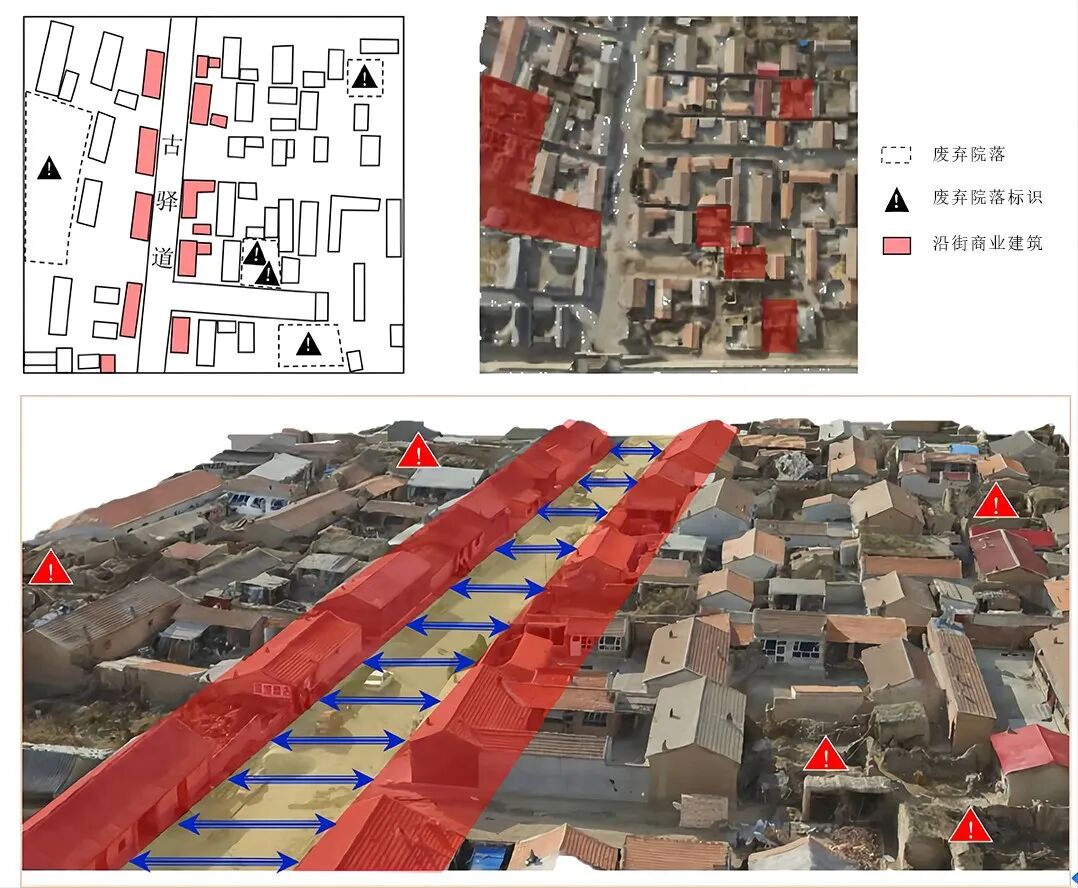
Figure 3 Identification of Special Buildings and Courtyards within 3D Models
4 Conclusions
This paper elaborates methods to extract quantifiable urban morphological indicators from 3D models generated by UAV oblique photogrammetry, establishing a recognizable spatial data foundation for comprehensive urban morphological research. Amid rapid functional transformation of villages and towns, the proposed methodology delivers an efficient data acquisition channel for urban planning practices.
Author Profiles
Zhang Chun, Professor, School of Architecture and Design, Beijing Jiaotong University
Liu Yuanyuan, Master’s Student, School of Architecture and Design, Beijing Jiaotong University
Dai Cheng, Graduate, School of Architecture and Design, Beijing Jiaotong University
Jin Jiaxuan, Master’s Candidate, Department of Urban Planning, University College London (UCL)
Yuan Yuan, Engineer, Urban-Rural Planning Bureau, Zhangjiakou Economic Development Zone

